
If you're looking for an interesting longer read, go to this webpage:
http://www.statewidetitle.com/NewsletterFull.asp?Issue=214
But if you want the shortened version, and being that you're reading a blog you probably do, here you go.
Back in 1772, the boundary line between North Carolina and South Carolina was "officially" surveyed and I use the term officially because while the surveyors were picked by the governors of each state, that's about as official as it got.

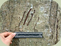
This highly accurate map represents what North and South Carolina might have looked like shortly before the American Revolution. Apparently, no one in 1772 knew what the names of the colonies above Maryland were called. The surveys were done by marking trees every mile but they did not use permanent markings or measurements of any kind to demonstrate the length of distance between the trees. So in short, individuals, likely educated individuals, were appointed by governors who were representatives of the King of England to identify a boundary line between two colonies, each with their own set of laws and customs, by.....marking trees in the woods.

I realize this seems extremely ineffective, because it is, but if that wasn't scary enough, no one thought that maybe we should use a more effective method to check the border until 1996. That's correct, we were relying on tree markings that were 224 years old until the late 90's to determine where our states are.
So one would hope a proper survey has now been done, because apparently Google Earth can find my house, but surveyors can't. What are the ramifications you might wonder? Well, a doctor's office has been located in a state he isn't licensed to practiced in. Also, a fireworks stand that sells alcohol, presumably thought to once be in South Carolina, has actually been operating illegally in North Carolina. Can you imagine those people's day when they were told their entire business had been operating illegally?

Apparently, the current surveyors were not able to locate any of the old trees. Also it became obvious that the original 1772 survey line didn't run exactly straight, causing a bigger issue of where the boundary actually was meant to lie.

Both states have proposed solutions to the issue, which you're welcome to read, but don't expect a resolution anytime soon. Thanks again founding fathers for proving why Americans don't think math is important.
No comments:
Post a Comment